| Description |
|---|
| Material: | Not Provided |
| Classification: | Not Provided |
| Field Name: | KK820316-4 STA52 RD28 |
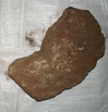
| Description: | Total wt? 50 kg. The rocks recovered include a variety of metamorphosed oceanic rock types - principally plutonic volcanic rocks that have undergone grenschist- to amphibolite-grade metamorphism. Rock types include metagabbros metadolerite metabasalt and breccias primarily composed of fragments of the metamorphosed volcanics. A majority of the samples are large (> 5 kg) blocks of amphibolitized (uralitized) gabbro with coarse crystals of amphibole (after Cpx) and plagioclase (albitized?). Some of these samples show megascopic features of tectonism (ie crushing, cataclasis, sliken sides). Lesser amount of metabasalt and metadolerite are also epidotized and chloritized. All ingenous rx show veining and replacement by calcite and qtz. Sedimentary rocks include: coarse sandstones, conglomerates, breccias and foram-rich calcareous siltstone. Coarser rocks contain abundant clasts of metabasalt and metadolerite. Moderate sorting of subrounded clasts in s.s., silicate cement. 10% forams in calc-siltstone. Two bags each for HIG and Sol. Is. |
| Age (min): | Not Provided |
| Age (max): | Not Provided |
| Collection Method: | Dredge |
| Collection Method Description: | Not Provided |
| Size: | Not Provided |
| Geological Age: | Not Provided |
| Geological Unit: | Not Provided |
| Comment: | Three buckets of samples labeled 1, 2 and 2 available. |
| Purpose: | Geological Studies |
| Geolocation |
|---|
| Latitude Start (WGS84): | -8.03917 |
| Latitude End: | Not Provided |
| Longitude Start (WGS84): | 155.7638 |
| Longitude End: | Not Provided |
| Northing (m) (UTM NAD83): | Not Provided |
| Easting (m) (UTM NAD83): | Not Provided |
| Zone: | Not Provided |
| Vertical Datum: | Not Provided |
| Elevation Start: | Not Provided |
| Elevation End: | Not Provided |
| Nav Type: | Not Provided |
| Physiographic Feature: | Not Provided |
| Name Of Physiographic Feature: | Not Provided |
| Location Description: | Woodlark Basin near Woodlark Ridges-Depth start (m) 3,350. Depth finish (m) 2,970. |
| Locality: | Not Provided |
| Locality Description: | Not Provided |
| Country: | Not Provided |
| State/Province: | Not Provided |
| County: | Not Provided |
| City: | Not Provided |
| Collection |
|---|
| Field Program/Cruise: | KK820316-4 |
| Platform Type: | Not Provided |
| Platform Name: | Not Provided |
| Platform Description: | Not Provided |
| Launch Type: | Not Provided |
| Launch Platform Name: | Not Provided |
| Launch ID: | Not Provided |
| Collector/Chief Scientist: | Not Provided |
| Collector/Chief Scientist Detail: | Not Provided |
| Collection Start Date: | 1982-05-30T04:00:00Z |
| Collection End Date: | Not Provided |
| Curation |
|---|
| Current Archive: | Not Provided |
| Current Archive Contact Details: | Not Provided |
| Original Archive: | Not Provided |
| Original Archive Contact Details: | Not Provided |
| Related Samples |
|---|
Parents: | No Parents | | Siblings: | No Siblings |
| Children: | No Children |
| Relevant Documents: |
|---|
|


 STA52 RD28.JPG (primary image)


