| Description |
|---|
| Material: | Not Provided |
| Classification: | Not Provided |
| Field Name: | KK820316-4 STA60 RD35 |
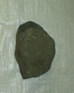
| Description: | 500-600 kg of cobble to boulder-size rocks. > 80% of the rocks were very fresh with angular broken surfaces. Some of the samples had coatings of sulfur and/or sulfides; these were associated with samples that showed some degree of hydrothermal alteration or oxidation. In some cases the mineralization extended into vesicles within the rocks, but more typically was confined to surfaces and fractures. The contents of the dredge were similar to the previous dredge (RD 34) on Kavachi but may be more diversified. The primary rock types (> 70%) are ol-pyroxene phyric basalts, ol-plag phyric basalts, and ol-pyrox-plag basalts. The predominance of cpx-rich volcanics is noted; some with cm-size euhedral crystals. Most of the rocks are vesicular (5-20% vesicles) but some (<5%) are pumacious. A small number (<5%) of basaltic agglomerates are also present. Most (> 80%) of the rocks are fresh. ~5 bags of undescribed rocks to Solomons, 1 bag of described samples. ~4 bags of undescribed rocks to HIG, 1 (2?) of described samples. Note: Kavachi went about 300 m to NE at nearest- discoloured intermittent slick. |
| Age (min): | Not Provided |
| Age (max): | Not Provided |
| Collection Method: | Dredge |
| Collection Method Description: | Not Provided |
| Size: | Not Provided |
| Geological Age: | Not Provided |
| Geological Unit: | Not Provided |
| Comment: | Eight buckets of samples-each individually labeled. Four buckets labeled 1, two buckets labeled 3, two buckets labeled 4. |
| Purpose: | Geological studies |
| Geolocation |
|---|
| Latitude Start (WGS84): | -9.0106667 |
| Latitude End: | Not Provided |
| Longitude Start (WGS84): | 157.97733 |
| Longitude End: | Not Provided |
| Northing (m) (UTM NAD83): | Not Provided |
| Easting (m) (UTM NAD83): | Not Provided |
| Zone: | Not Provided |
| Vertical Datum: | Not Provided |
| Elevation Start: | Not Provided |
| Elevation End: | Not Provided |
| Nav Type: | Not Provided |
| Physiographic Feature: | Not Provided |
| Name Of Physiographic Feature: | Not Provided |
| Location Description: | Just S.W. of Kavachi Sation. Depth start (m) 410. Depth finish (m) 380. |
| Locality: | Not Provided |
| Locality Description: | Not Provided |
| Country: | Not Provided |
| State/Province: | Not Provided |
| County: | Not Provided |
| City: | Not Provided |
| Collection |
|---|
| Field Program/Cruise: | KK820316-4 |
| Platform Type: | Not Provided |
| Platform Name: | Not Provided |
| Platform Description: | Not Provided |
| Launch Type: | Not Provided |
| Launch Platform Name: | Not Provided |
| Launch ID: | Not Provided |
| Collector/Chief Scientist: | Not Provided |
| Collector/Chief Scientist Detail: | Not Provided |
| Collection Start Date: | 1982-06-04T04:00:00Z |
| Collection End Date: | Not Provided |
| Curation |
|---|
| Current Archive: | Not Provided |
| Current Archive Contact Details: | Not Provided |
| Original Archive: | Not Provided |
| Original Archive Contact Details: | Not Provided |
| Related Samples |
|---|
Parents: | No Parents | | Siblings: | No Siblings |
| Children: | No Children |
| Relevant Documents: |
|---|
|


 STA60 RD35.JPG (primary image)


