| Description |
|---|
| Material: | Not Provided |
| Classification: | Not Provided |
| Field Name: | KK820316-4 STA59 RD34 |
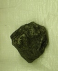
| Description: | ~ 600 kg of cobble to boulder size ingneous rocks; > 90% are fresh with angular surfaces. The majority of samples (> 90%) are mafic basalts that vary from Cpx-rich porphytic varieties to Cpx-ol phyric and plag-phyric types. There appears to be a complete continuum between the various types but Cps-rich varieties are dominant. Picritic and plag-phyric types comprise < 20% of the total. A few volcaniclastic breccias are present; one is coated by sulfur and alters ~ 30% of the rock.One unusual sample is an amphibole xenocryst andesite with 10-15% euhedral amphibole phenocryst (xenocrysts?). None of the samples have significant amounts of glass or glassy margins, many are vesicular but this varies from 1% to 50% in more pumacous types. 3 Bags of undescribed rocks for Solomon Is. 4 Bags of undescribed rocks for HIG. 1 Bag each of described samples for HIG and SI. |
| Age (min): | Not Provided |
| Age (max): | Not Provided |
| Collection Method: | Dredge |
| Collection Method Description: | Not Provided |
| Size: | Not Provided |
| Geological Age: | Not Provided |
| Geological Unit: | Not Provided |
| Comment: | Ten buckets of samples available- Two buckets labeled "A" one bucket labeled "B" Two buckets labeled 1, two buckets labeled 2, and three buckets individually labeled 5-7. |
| Purpose: | Geological studies |
| Geolocation |
|---|
| Latitude Start (WGS84): | -9.0015 |
| Latitude End: | Not Provided |
| Longitude Start (WGS84): | 157.9925 |
| Longitude End: | Not Provided |
| Northing (m) (UTM NAD83): | Not Provided |
| Easting (m) (UTM NAD83): | Not Provided |
| Zone: | Not Provided |
| Vertical Datum: | Not Provided |
| Elevation Start: | Not Provided |
| Elevation End: | Not Provided |
| Nav Type: | Not Provided |
| Physiographic Feature: | Not Provided |
| Name Of Physiographic Feature: | Not Provided |
| Location Description: | S.E. of Kavachi Volcano. Depth start (m) 925. Depth finish (m) 870. |
| Locality: | Not Provided |
| Locality Description: | Not Provided |
| Country: | Not Provided |
| State/Province: | Not Provided |
| County: | Not Provided |
| City: | Not Provided |
| Collection |
|---|
| Field Program/Cruise: | KK820316-4 |
| Platform Type: | Not Provided |
| Platform Name: | Not Provided |
| Platform Description: | Not Provided |
| Launch Type: | Not Provided |
| Launch Platform Name: | Not Provided |
| Launch ID: | Not Provided |
| Collector/Chief Scientist: | Not Provided |
| Collector/Chief Scientist Detail: | Not Provided |
| Collection Start Date: | 1982-06-03T04:00:00Z |
| Collection End Date: | Not Provided |
| Curation |
|---|
| Current Archive: | Not Provided |
| Current Archive Contact Details: | Not Provided |
| Original Archive: | Not Provided |
| Original Archive Contact Details: | Not Provided |
| Related Samples |
|---|
Parents: | No Parents | | Siblings: | No Siblings |
| Children: | No Children |
| Relevant Documents: |
|---|
|


 STA59 RD34.JPG (primary image)


