| Description |
|---|
| Material: | Not Provided |
| Classification: | Not Provided |
| Field Name: | KK820316-4 STA57 RD33 |
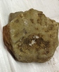
| Description: | 300 kg - 3/4 of dredge was full: top 3/4 was full of cobble size pumice with tan to light grey color containing mineral phenocrysts, fragments and pumaceous rock fragments. The bottom 1/4 of the bag was filled with vitrophyric basalts which commonly had a pitchstone-like surface with concordal fractures. These basalts have variable percentages of vesicles and in some cases grade into lighter-colored pumaceous basalt. Typical pumice cobble: tan to lt-grey with 80-90% clear to tan glass in sheaths and strings, These strands are welded together to form denser rock sections most show preferred linear flow orientation and flow bonding. They contain pumice shards as well as mineral grains and clost (plagioclase, magnetite, cpx). Basalts are glassy to finely crystalline with plag, cpx, magnetite +- ol. Some of the volcanics may be basaltic andesites or andesite. Phenocryst contents vary from ~5% to ~35%, vesicle content 5%-70%. 2 bags pumice to Sol. Is., 1 bag of described samples SI. 2 bags pumice to HIG, 1 bag of described samples HIG. |
| Age (min): | Not Provided |
| Age (max): | Not Provided |
| Collection Method: | dredge |
| Collection Method Description: | Not Provided |
| Size: | Not Provided |
| Geological Age: | Not Provided |
| Geological Unit: | Not Provided |
| Comment: | Four buckets of samples available-each individually labeled 2,2,3, and 4. |
| Purpose: | Geological studies |
| Geolocation |
|---|
| Latitude Start (WGS84): | -8.7351667 |
| Latitude End: | Not Provided |
| Longitude Start (WGS84): | 157.05633 |
| Longitude End: | Not Provided |
| Northing (m) (UTM NAD83): | Not Provided |
| Easting (m) (UTM NAD83): | Not Provided |
| Zone: | Not Provided |
| Vertical Datum: | Not Provided |
| Elevation Start: | Not Provided |
| Elevation End: | Not Provided |
| Nav Type: | Not Provided |
| Physiographic Feature: | Not Provided |
| Name Of Physiographic Feature: | Not Provided |
| Location Description: | Ridge S.W. of Rendova. Depth start (m) 1,550 and depth finish (m) 1,250 |
| Locality: | Not Provided |
| Locality Description: | Not Provided |
| Country: | Not Provided |
| State/Province: | Not Provided |
| County: | Not Provided |
| City: | Not Provided |
| Collection |
|---|
| Field Program/Cruise: | KK820316-4 |
| Platform Type: | Not Provided |
| Platform Name: | Not Provided |
| Platform Description: | Not Provided |
| Launch Type: | Not Provided |
| Launch Platform Name: | Not Provided |
| Launch ID: | Not Provided |
| Collector/Chief Scientist: | Not Provided |
| Collector/Chief Scientist Detail: | Not Provided |
| Collection Start Date: | 1982-06-03T04:00:00Z |
| Collection End Date: | Not Provided |
| Curation |
|---|
| Current Archive: | Not Provided |
| Current Archive Contact Details: | Not Provided |
| Original Archive: | Not Provided |
| Original Archive Contact Details: | Not Provided |
| Related Samples |
|---|
Parents: | No Parents | | Siblings: | No Siblings |
| Children: | No Children |
| Relevant Documents: |
|---|
|


 STA57 RD33 (3).JPG (primary image)


