| Description |
|---|
| Material: | Not Provided |
| Classification: | Not Provided |
| Field Name: | KK820316-4 STA49 RD26 |
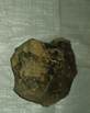
| Description: | Total recovery 600 lbs (~250 kg) of oceanic basalt from within the median rift valley. Approximately 70% of samples have glassy rims and margins (generally < 1 cm). At least 50% have features that indicate they were extruded onto the sea-floor as pillows or lava tubes. Some non-glassy fragments may have been parts of pillows but subsequently lost their glassy rinds. Only ~ 5% of samples are slightly coarse grained and holocrystalline - these maybe interior of flows or dikes. About 85% of the samples have rough, crumbly coating that appears oxidized, palagonitized and Mn- coated. 15% are extensively Mn- coated (< 1 cm thick). All samples are extremely fresh - with alteration constrained to pillow margins or along major fractures. The angular nature of the samples suggest they were recovered in situ. Also: 20 lbs foram-rich dull yellow orange mud. 15% forams, some sponge spiculas and diatoms in clay matrix. 3 plastic bags: Exon, HIG, Solomons. 21 samples were described in detail and glass splits were taken for analysis. Larger splits of these were put in a separate bag for B. Taylor (HIG). Extra samples were distributed to: 3 Bags Solomons; 3 Bags HIG. |
| Age (min): | Not Provided |
| Age (max): | Not Provided |
| Collection Method: | Dredge |
| Collection Method Description: | Not Provided |
| Size: | Not Provided |
| Geological Age: | Not Provided |
| Geological Unit: | Not Provided |
| Comment: | Six buckets of samples individually labeled 1-3 and two buckets labeled "A". |
| Purpose: | Geological studies |
| Geolocation |
|---|
| Latitude Start (WGS84): | -9.499 |
| Latitude End: | Not Provided |
| Longitude Start (WGS84): | 155.41917 |
| Longitude End: | Not Provided |
| Northing (m) (UTM NAD83): | Not Provided |
| Easting (m) (UTM NAD83): | Not Provided |
| Zone: | Not Provided |
| Vertical Datum: | Not Provided |
| Elevation Start: | Not Provided |
| Elevation End: | Not Provided |
| Nav Type: | Not Provided |
| Physiographic Feature: | Not Provided |
| Name Of Physiographic Feature: | Not Provided |
| Location Description: | Woodlark Basin. Depth start (m) 3,830. Depth finish (m) 3,460. |
| Locality: | Not Provided |
| Locality Description: | Not Provided |
| Country: | Not Provided |
| State/Province: | Not Provided |
| County: | Not Provided |
| City: | Not Provided |
| Collection |
|---|
| Field Program/Cruise: | KK820316-4 |
| Platform Type: | Not Provided |
| Platform Name: | Not Provided |
| Platform Description: | Not Provided |
| Launch Type: | Not Provided |
| Launch Platform Name: | Not Provided |
| Launch ID: | Not Provided |
| Collector/Chief Scientist: | Not Provided |
| Collector/Chief Scientist Detail: | Not Provided |
| Collection Start Date: | 1982-05-28T04:00:00Z |
| Collection End Date: | Not Provided |
| Curation |
|---|
| Current Archive: | Not Provided |
| Current Archive Contact Details: | Not Provided |
| Original Archive: | Not Provided |
| Original Archive Contact Details: | Not Provided |
| Related Samples |
|---|
Parents: | No Parents | | Siblings: | No Siblings |
| Children: | No Children |
| Relevant Documents: |
|---|
|


 STA49 RD26.JPG (primary image)


