| Description |
|---|
| Material: | Not Provided |
| Classification: | Not Provided |
| Field Name: | KK820316-4 STA40 RD24 |
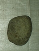
| Description: | Recovered approximately 400 kg. of basaltic volcanics and subaqueous volcanoclastics. 18 volcanic rocks were cut and described in detail, splits of each went to HIG and Solomons Survey. 22 clastic rocks were sampled and described, splits of each went to HIG and Solomons. 1 additional bag of each type (basalt + clastic) was also made up for HIG and Solomons Survey. Basalt: 20% highly cpx, ol phyric (>30% phenos), 50% plag + cpx phyric (5-20% pl, 1-3% cpx), the remaining samples cosist entirely of cpx, ol, plag phyric (< 5%) and aphyric basalts. Generally they are very fresh to glassy. Glasses were found as outer rinds on 5 samples that are petrographically similar, maybe one flow entering the sea. One basalt contains perdotite xenoliths (< 2 cm diam) and some leucocratic (tonalite?) xenoliths. most of the lavas were angular rather than rounded and are probably subaenal and/or dervied from New Georgia. Clastics: silty sandstones, volcanic breccias, hyaloclastites, calcareous silt and sandstones. hyaloclastites have high proportions of glass (some fresh) and mineral fragments. Some sandstones are interbedded but most are f.g and well sorted, well indurated. a few % (1-2%) forams present in calcareous siltstones. 2 bags each for Sol + HIG. |
| Age (min): | Not Provided |
| Age (max): | Not Provided |
| Collection Method: | Dredge |
| Collection Method Description: | Not Provided |
| Size: | Not Provided |
| Geological Age: | Not Provided |
| Geological Unit: | Not Provided |
| Comment: | Six bags of samples available each individually labeled 1-3. |
| Purpose: | Geological studies |
| Geolocation |
|---|
| Latitude Start (WGS84): | -8.8115 |
| Latitude End: | Not Provided |
| Longitude Start (WGS84): | 157.2595 |
| Longitude End: | Not Provided |
| Northing (m) (UTM NAD83): | Not Provided |
| Easting (m) (UTM NAD83): | Not Provided |
| Zone: | Not Provided |
| Vertical Datum: | Not Provided |
| Elevation Start: | Not Provided |
| Elevation End: | Not Provided |
| Nav Type: | Not Provided |
| Physiographic Feature: | Not Provided |
| Name Of Physiographic Feature: | Not Provided |
| Location Description: | Woodlark Basin, S. of new Georgia IS. Depth start (m) 3,405. |
| Locality: | Not Provided |
| Locality Description: | Not Provided |
| Country: | Not Provided |
| State/Province: | Not Provided |
| County: | Not Provided |
| City: | Not Provided |
| Collection |
|---|
| Field Program/Cruise: | KK820316-4 |
| Platform Type: | Not Provided |
| Platform Name: | Not Provided |
| Platform Description: | Not Provided |
| Launch Type: | Not Provided |
| Launch Platform Name: | Not Provided |
| Launch ID: | Not Provided |
| Collector/Chief Scientist: | Not Provided |
| Collector/Chief Scientist Detail: | Not Provided |
| Collection Start Date: | 1982-05-23T04:00:00Z |
| Collection End Date: | Not Provided |
| Curation |
|---|
| Current Archive: | Not Provided |
| Current Archive Contact Details: | Not Provided |
| Original Archive: | Not Provided |
| Original Archive Contact Details: | Not Provided |
| Related Samples |
|---|
Parents: | No Parents | | Siblings: | No Siblings |
| Children: | No Children |
| Relevant Documents: |
|---|
|


 STA40 RD24.JPG (primary image)


