| Description |
|---|
| Material: | Not Provided |
| Classification: | Not Provided |
| Field Name: | KK820316-4 STA37 RD23 |
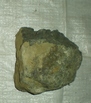
| Description: | Two bag: - 1 HIG; - 1 Solomon Is. Geol Survey. Total recovery ~50 kg of cobble to boulder size rocks. Approximately 1/2 was vesicular basaltic volcanic rock and holocrystalline dolerites. The remainder of the samples were various types of volcanoclastics including one large (~15-20 kg) boulder. Another 15-kgs was various clay-ash-clastic partially indurated clays (put in bag #1). The basaltic rocks are primarily olivine-Cpx-plag phyric basalts with 5-30% vesicles. The most abundant basalt type is Cpx-rich with lesser 01+/- plag. One possible trochyandesite and a tonalite (xenolith) were also recovered. All of the samples are reasonably fresh (< 10% replaced), but the amounts of secondary minerals in vesicles varies from 0 - 60%. None of the samples were glassy - most appear to be fragments of flows. Their rounded nature suggests they have had some history of erosion and redeposition. Some of the lavas were enclosed in volcanoclastic material. One basalt contains a xenolith of tonalite. Less than 10% of the rocks were ophyric, there may have been dikes. 35 samples have veeb cut + described for later analysis. The volcaniclastics very from strongly indunated lithic rudites, lithic tuffs, crystal tuffs to silty volcanic sandstones (which also act as matrices for the basalt cobbles. |
| Age (min): | Not Provided |
| Age (max): | Not Provided |
| Collection Method: | Dredge |
| Collection Method Description: | Not Provided |
| Size: | Not Provided |
| Geological Age: | Not Provided |
| Geological Unit: | Not Provided |
| Comment: | Two buckets of samples available individually labeled 1 and 2 |
| Purpose: | Geological studies |
| Geolocation |
|---|
| Latitude Start (WGS84): | -9.0801667 |
| Latitude End: | Not Provided |
| Longitude Start (WGS84): | 157.73883 |
| Longitude End: | Not Provided |
| Northing (m) (UTM NAD83): | Not Provided |
| Easting (m) (UTM NAD83): | Not Provided |
| Zone: | Not Provided |
| Vertical Datum: | Not Provided |
| Elevation Start: | Not Provided |
| Elevation End: | Not Provided |
| Nav Type: | Not Provided |
| Physiographic Feature: | Not Provided |
| Name Of Physiographic Feature: | Not Provided |
| Location Description: | Solomon IS. (S. of new Georgia) Depth start (m) 3,095. Depth finish (m) 2,525. |
| Locality: | Not Provided |
| Locality Description: | Not Provided |
| Country: | Not Provided |
| State/Province: | Not Provided |
| County: | Not Provided |
| City: | Not Provided |
| Collection |
|---|
| Field Program/Cruise: | KK820316-4 |
| Platform Type: | Not Provided |
| Platform Name: | Not Provided |
| Platform Description: | Not Provided |
| Launch Type: | Not Provided |
| Launch Platform Name: | Not Provided |
| Launch ID: | Not Provided |
| Collector/Chief Scientist: | Not Provided |
| Collector/Chief Scientist Detail: | Not Provided |
| Collection Start Date: | 1982-05-21T04:00:00Z |
| Collection End Date: | Not Provided |
| Curation |
|---|
| Current Archive: | Not Provided |
| Current Archive Contact Details: | Not Provided |
| Original Archive: | Not Provided |
| Original Archive Contact Details: | Not Provided |
| Related Samples |
|---|
Parents: | No Parents | | Siblings: | No Siblings |
| Children: | No Children |
| Relevant Documents: |
|---|
|


 STA37 RD23.JPG (primary image)


