| Description |
|---|
| Material: | Not Provided |
| Classification: | Not Provided |
| Field Name: | KK810626-5 STA96 RD70 |
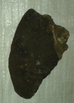
| Description: | 4 bags + lab samples. Approx. 600 lbs (270 kgs) of rocks. South side of north seamount dredged. Of the samples obtained, four thin sections were made: A1 - Augite, plagioclase, olivine main mineral components. Subophitic texture. Plag. Laths enclosed by subhedral augite in a fine grained intergranular to hyalopilitic groundmass containing glass + opaques. Olivine highly altered. Olivine, plag, augite basalt - Alkali basalt. B1 - This plag. laths, Olivine rimmed w/ iddingsite, corroded or resorbed augite, intergranular opaques, vesicle filling carbonates. Vesicular texture, pilotaxitic to subvariolitic plag.texture. Hawaiite or vesicular Alkaliolivine basalt. C1 - Highly altered olivine, Augite, plagioclase intergrowths w/ Augite. Texture - subophitic to subvariolitic plag. w/ augite with glassy interstital groundmass. Fine grained Iddingsite - plag basalt. D1 - Subhedral augite, altered plag. laths, chert nodules or vesicle fillings (?), iddingsit; texture subvariolitic plag laths, vesicles filled; w/ chert or chert nodules entrained in flow; Highly altered alkali-olivine basalt or Iddingsite-plag basalt. In addition, there were several carbonate cemented breccias which may be tectonic judging from variable fragment types. Rocks included - volcaniclastic breccia (w/ vesicular basalt cobbles) and chert nodules surrounded by phosphatized (?) carbonate. |
| Age (min): | Not Provided |
| Age (max): | Not Provided |
| Collection Method: | Dredge |
| Collection Method Description: | Not Provided |
| Size: | Not Provided |
| Geological Age: | Not Provided |
| Geological Unit: | Not Provided |
| Comment: | 8 buckets of samples individually labeled 1-4 available. |
| Purpose: | Geological studies |
| Geolocation |
|---|
| Latitude Start (WGS84): | 18.20333 |
| Latitude End: | Not Provided |
| Longitude Start (WGS84): | 171.1433 |
| Longitude End: | Not Provided |
| Northing (m) (UTM NAD83): | Not Provided |
| Easting (m) (UTM NAD83): | Not Provided |
| Zone: | Not Provided |
| Vertical Datum: | Not Provided |
| Elevation Start: | Not Provided |
| Elevation End: | Not Provided |
| Nav Type: | Not Provided |
| Physiographic Feature: | Not Provided |
| Name Of Physiographic Feature: | Not Provided |
| Location Description: | Mid Pacific Seamounts. Depth start (m) 1,900 and depth finish (m) 1,700. |
| Locality: | Not Provided |
| Locality Description: | Not Provided |
| Country: | Not Provided |
| State/Province: | Not Provided |
| County: | Not Provided |
| City: | Not Provided |
| Collection |
|---|
| Field Program/Cruise: | KK810626-5 |
| Platform Type: | Not Provided |
| Platform Name: | Not Provided |
| Platform Description: | Not Provided |
| Launch Type: | Not Provided |
| Launch Platform Name: | Not Provided |
| Launch ID: | Not Provided |
| Collector/Chief Scientist: | Not Provided |
| Collector/Chief Scientist Detail: | Not Provided |
| Collection Start Date: | 1981-11-04T05:00:00Z |
| Collection End Date: | Not Provided |
| Curation |
|---|
| Current Archive: | Not Provided |
| Current Archive Contact Details: | Not Provided |
| Original Archive: | Not Provided |
| Original Archive Contact Details: | Not Provided |
| Related Samples |
|---|
Parents: | No Parents | | Siblings: | No Siblings |
| Children: | No Children |
| Relevant Documents: |
|---|
|


 STA96 RD70.JPG (primary image)


